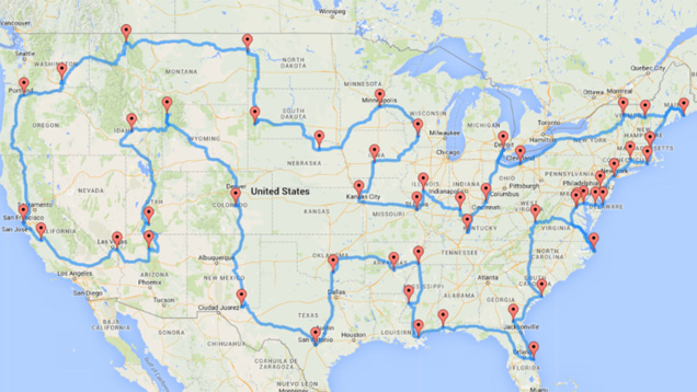
The perfect road trip across the US would take you to all the must-see landmarks and historical sites and minimise unnecessary driving, but figuring out the ideal path isn’t easy. CS graduate research assistant and data tinkerer Randal Olson created an algorithm to solve this problem and come up with an epic road trip.
You can read about the computing details in the link below, but here are the trip details for those itching to embark on this journey: You’ll be driving and stopping in all 48 continguous US states; visiting only national natural landmarks, historic sites, parks and monuments; and never leaving the US.
All in all, it’s some 22,000 kilometres of driving — about 9.33 days of driving time, assuming no traffic. The landmarks n the list include the Grand Canyon, the Alamo, Liberty Bell, Statue of Liberty, Mammoth Cave National Park, Taliesin, Lost World Caverns and Mount Rushmore.
If you’re more cosmopolitan than outdoorsy, Olson also has a bonus road trip map that uses TripAdvisor’s Best City to Visit list, so you can drive your way across the US visiting the top city in each state. Except for North Dakota, Vermont, and West Virginia, that is. Because apparently out of 400 recommended cities to visit, those states do not have any worthwhile cities, according to TripAdvisor members. Either way, it’s an interesting approach if you want to take a lengthy US road trip.
Computing the optimal road trip across the U.S. [Randal S. Olson]
Comments