Strava’s heatmap isn’t new, but it wasn’t until recently that I really looked at it. This interactive tool shows where Strava users run, bike, swim, kayak, ski and snowshoe — and you can separate those activities as you browse the map. Want to look for secret swimming holes? Check which high schools have a track that’s open to the public? The heatmap will tell you.
You don’t have to use Strava yourself to browse the heatmap, but you will need a free Strava account to zoom in to street level.
A note about privacy
The data on the heatmap comes from Strava users’ tracked routes. So if you use Strava yourself, this is your reminder that you’ll probably want to use the privacy zone feature to exclude your house or any other areas you’d rather not have your run tracked.
Find safe routes
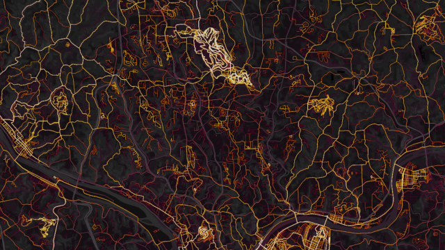
I live in a hilly area where many of the roads are congested and lacking footpaths. I mainly stick to familiar neighbourhoods and park paths because I know they will be safe to run or bike on. But the heatmap gives me a way to figure out which roads I might want to try, and which ones are likely not as safe.
For example, one of the major roads in my area appears dark on the heatmap — a good sign that it doesn’t have a shoulder you can bike or jog on. (Having driven this road, it’s true.) But looking for bright areas, I see several clusters of roads and paths that are worth looking into. There’s a cemetery with a bunch of paths that are popular with runners, for example, and several small neighbourhoods that appear to be little oases of easy jogging in-between busier roads.
Find new trails
Many parks, schools, and other areas have little-known trails on their property, which you might not know if you haven’t been there. With the heatmap, though, I can easily see that several popular park paths are surrounded by strong wiggly lines that head off into the woods. Sometimes, you’ll also see the signs of routes that you can run around a place, offering a way to tack on a few miles to your track workout by jogging on neighbourhood roads.
Browse around the map to find likely options, then check out park websites or signs posted in the area for more information on what the trails are like and how to follow them.
Look for ovals
High schools often have running tracks that are open to local residents; so do some middle schools, community centres, and other spots you might not have realised. Set the heatmap’s filters to the little shoe icon (which shows running, walking, and hiking) and look for ovals. When you find one, use the “Labels” layer to find out the name of the school or location. Switch the layer to biking, and you may even find a few bike tracks.
As before, check out the hours and rules on the place’s website or look for signs posted in the area. The heatmap gives you clues, not permission.
Find pools and swimming holes
There’s a layer with a water icon too, which is handy for finding places where people commonly swim or engage in other water activities. One large public swimming pool shows several horizontal tracks across the pool, representing the location of the lap lanes. (I’ve been there; that’s exactly where the lap lanes are.)
You can also use this feature to find the beaches most popular for swimming, and if you’re inland, you can use it to find small lakes or ponds where people like to swim.
Just be aware that the water icon is for swimming and other water sports like paddleboarding and kayaking. One local lake shone bright on the heatmap, but I know that swimming is not allowed there and I’ve never seen anyone do it. It is wildly popular for kayaking, though, and there are two boat rental places right on the lake. So it’s a good idea to cross-reference local business; if you were looking for a spot to bring your kayak or paddleboard, their presence would be a good hint.
Find spots to ski or snowshoe
There’s also a snowflake layer, which shows trails where people like to do winter sports like skiing and snowshoeing. Again, the heatmap doesn’t distinguish between the two, so do your own research to find out if you’ve really discovered a secret cross-country skiing trail. (I have also noticed a few activities that must have been mis-categorised, like a route on the swimming/water layer that is definitely located on roads.) But browsing around the map can give you an idea of where to start looking as you plan your next adventure.
Leave a Reply
You must be logged in to post a comment.