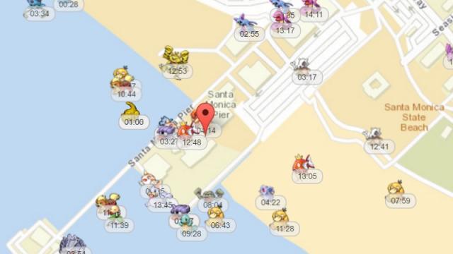
If you’re having a tough time finding certain Pokemon in Pokemon GO, PokeVision uses Niantic’s API to show you their actual locations, and how long they will be there.
There are a lot of Pokemon GO maps out there, but most of them, like the popular app Poke Radar, rely on the Pokemon GO community to post Pokemon locations. Because PokeVision uses Niantic’s API, however, it can show you exactly where every Pokemon is at the present moment, and for how long it’s going to be there before it disappears. I thought it sounded too good to be true, so I tried it out this morning. Sure enough, I was able to catch a Dratini in my area that had been evading me since launch. The downsides are you can’t filter by Pokemon type (yet), and there’s no app available for iOS or Android. You can only run it in a browser (but mobile browser seems to work fine). It’s hard to imagine Niantic wanting a service like this to exist, though, so who knows how long it will last. And personally, relying on a tool like this takes a lot of the fun out of Pokemon GO, so use at your own risk. If you want to check it out for yourself, head to the link below.
PokeVision Shows You The Real-Time Locations Of Pokemon In Pokemon GO
Comments
3 responses to “PokeVision Shows You The Real-Time Locations Of Pokemon In Pokemon GO”
Aware of this but not something I wish to use. Much more fun when you are able to hunt one down (hoping steps are fixed at some point) or the surprise when something awesome appears. Like the Aerodactyl the spawned in a park last night. Someone shouted it out and brought everyone running, haha.
You made my point for me “the steps glitch” makes it much less fun. Until then maps are the way to go
As someone who lives in the middle of nowhere, maybe ill be able to see if i should even bother with this 😛